Global S&T Development Trend Analysis Platform of Resources and Environment
| EIA’s mapping system and data series show energy infrastructure near Hurricane Ida | |
| admin | |
| 2021-08-27 | |
| 发布年 | 2021 |
| 语种 | 英语 |
| 国家 | 美国 |
| 领域 | 地球科学 |
| 正文(英文) | 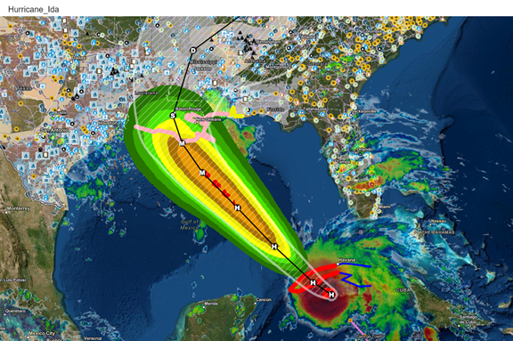
Source: U.S. Energy Information Administration, Energy Disruptions Map
This article was posted on Friday, August 27 at 4PM EST and will remain posted through Monday, August 30. Hurricane Ida is approaching the U.S. Gulf Coast region—home to key U.S. energy infrastructure—and is expected to make landfall on August 29. Hurricane Ida could affect local energy supply and demand, especially for transportation fuels and electricity. Our Energy Disruptions Map shows storm-related geographic data (also referred to as map layers) from the National Hurricane Center and the National Weather Service and map layers for energy-related infrastructure such as high-voltage transmission lines, power plants, and petroleum bulk terminals. We also publish key production, consumption, and operational status information. We collect and publish hourly electric load data for each of the 68 balancing authorities in the Lower 48 states in the U.S. Hourly Electric Grid Monitor. The effects of storms on electric load may become apparent in the data as long as balancing authorities can transmit information to us. For example, in September 2017, widespread outages following the landfall of Hurricane Irma resulted in electricity demand in Florida falling to 64% lower than typical levels for that time of year. Our Nuclear Outages status page maintains the daily status of each of the nation’s 57 nuclear power plants, based on status reports to the Nuclear Regulatory Commission. Louisiana has two nuclear power plants: Waterford Unit 3, located near New Orleans, and the River Bend nuclear power plant, located farther inland. Both facilities were operating at full capacity as of August 27. We collect and publish transportation fuels data regionally at the Petroleum Administration for Defense District (PADD) level. The Gulf Coast is a key region for U.S. petroleum infrastructure because it contains more than half of the U.S. petroleum refining capacity. 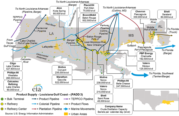
Source: U.S. Energy Information Administration, East Coast and Gulf Coast Transportation Fuels Markets
Typically, demand for transportation fuels increases rapidly in the days before the arrival of a hurricane in the affected areas as consumers purchase fuel to prepare for evacuation. This rapid, unexpected increase in demand puts pressure on local inventories because the rest of the supply chain has not had time to respond. Louisiana has declared a state of emergency ahead of Hurricane Ida’s landfall. Our Weekly Petroleum Status Report provides the most recent weekly estimates of regional petroleum markets. As of the week ending August 14, the Gulf Coast region had 84.9 million barrels of motor gasoline, or about 6% lower than last year in mid-August. Principal contributors: Kristen Tsai, Elesia Fasching Tags: weather, disruption |
| URL | 查看原文 |
| 来源平台 | U.S. Energy Information Administration |
| 文献类型 | 新闻 |
| 条目标识符 | http://119.78.100.173/C666/handle/2XK7JSWQ/336476 |
| 专题 | 地球科学 |
| 推荐引用方式 GB/T 7714 | admin. EIA’s mapping system and data series show energy infrastructure near Hurricane Ida. 2021. |
| 条目包含的文件 | 条目无相关文件。 | |||||
| 个性服务 |
| 推荐该条目 |
| 保存到收藏夹 |
| 查看访问统计 |
| 导出为Endnote文件 |
| 谷歌学术 |
| 谷歌学术中相似的文章 |
| [admin]的文章 |
| 百度学术 |
| 百度学术中相似的文章 |
| [admin]的文章 |
| 必应学术 |
| 必应学术中相似的文章 |
| [admin]的文章 |
| 相关权益政策 |
| 暂无数据 |
| 收藏/分享 |
除非特别说明,本系统中所有内容都受版权保护,并保留所有权利。


修改评论