Global S&T Development Trend Analysis Platform of Resources and Environment
| Dredging underway on Steeping River, Lincolnshire | |
| admin | |
| 2020-09-28 | |
| 发布年 | 2020 |
| 语种 | 英语 |
| 国家 | 英国 |
| 领域 | 资源环境 |
| 正文(英文) |
Press release
Dredging underway on Steeping River, LincolnshireWork has begun on removing silt from areas of the Steeping River and Wainfleet Relief Channel as part of extensive plans drawn up in the wake of last year’s flooding. 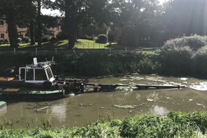
The dredger boat will target isolated pockets of silt over the next few months The dredging operation will remove sediment from targeted locations across 5.5km of waterway. The stretch includes 5km of river between Thorpe Culvert and Dovecotes Farm, and 650m of the eastern end of the relief channel. The specific locations being targeted within those stretches are where silt has built up higher than is ideal for maintaining a free flow of water. This first phase of dredging is expected to last several months and will be followed by a second stage next autumn, tackling areas of sediment across 1.2km of the western end of the relief channel. The timings are subject to change. The amount of silt in the river and relief channel was surveyed last autumn. Findings showed that overall levels of sediment had reduced by 20% since the last investigation in 2014 – but that more had accumulated in certain isolated pockets. The dredging work will tackle those pockets, across which silt is an average of 43cm higher than desired. Authorities have always acknowledged that dredging alone does not reduce flood risk in the Steeping – and would not have prevented last year’s breach. The Environment Agency and its partners agree there is no single solution that can eliminate flood risk. But that it can be reduced using a combination of methods. Such a combination, including dredging, is proposed in wide-ranging plans to reduce the risk of a repeat of last year’s flooding. The Steeping Catchment Action Plan outlines the actions that public sector organisations and the community can take to become more resilient to flooding and the impacts of climate change. It is the result of extensive investigations into how flood risk is managed across the entire area – and what actions will provide the most benefit in reducing future risk. Dredging is just one part of those plans. Also included are options to improve the flow of water, boost community resilience, further strengthen and maintain defences, and hold back or store flood water. Exactly which approaches are taken long-term depends on funding. But the plan is exploring and developing new, innovative ways of financing the work. The plan was launched in April 2020 by a steering group of local authorities and community representatives, formed to focus attention on solutions for the areas hit by last year’s flooding. On 12 June 2019, intense rain led to the breach of the Wainfleet Relief Channel, sparking a massive emergency response, including military. Just two days before the breach was the wettest day ever recorded in June and in Wainfleet. The area saw 74.6mm of rain in just one day. That is around 40% higher than the average for that time of year, and 75% more than the last major flood in June 2007. This record-breaking rainfall has been identified as the main cause of the breach. In total, 88 properties were affected across six parishes in the East Lindsey district, with Wainfleet All Saints the hardest hit. Morgan Wray, flood and coastal erosion risk manager at the Environment Agency, said:
Robert Caudwell, chairman of the Steeping Steering Group, said:
Andrew McGill, chief executive of Lindsey Marsh Drainage Board, said:
The steering group is a partnership made up of the Environment Agency, Lincolnshire County Council, East Lindsey District Council, the National Farmers’ Union, Lindsey Marsh Drainage Board and Witham Fourth Internal Drainage Board. The dredging operating is managed by Lindsey Marsh Drainage Board. You can sign up to the EA’s Flood Warning Service to get advanced notice of any expected flooding – call Floodline on 0345 988 1188 or visit gov.uk/flood, where you can also find out what actions you can take to prepare for the worst.
Published 28 September 2020
|
| URL | 查看原文 |
| 来源平台 | UK Environment Agency |
| 文献类型 | 新闻 |
| 条目标识符 | http://119.78.100.173/C666/handle/2XK7JSWQ/296612 |
| 专题 | 资源环境科学 |
| 推荐引用方式 GB/T 7714 | admin. Dredging underway on Steeping River, Lincolnshire. 2020. |
| 条目包含的文件 | 条目无相关文件。 | |||||
| 个性服务 |
| 推荐该条目 |
| 保存到收藏夹 |
| 查看访问统计 |
| 导出为Endnote文件 |
| 谷歌学术 |
| 谷歌学术中相似的文章 |
| [admin]的文章 |
| 百度学术 |
| 百度学术中相似的文章 |
| [admin]的文章 |
| 必应学术 |
| 必应学术中相似的文章 |
| [admin]的文章 |
| 相关权益政策 |
| 暂无数据 |
| 收藏/分享 |
除非特别说明,本系统中所有内容都受版权保护,并保留所有权利。


修改评论