Global S&T Development Trend Analysis Platform of Resources and Environment
| The Nili Fossae grabens on Mars | |
| admin | |
| 2018-11-22 | |
| 发布年 | 2018 |
| 语种 | 英语 |
| 国家 | 德国 |
| 领域 | 地球科学 |
| 正文(英文) |
The transition between highlands and lowlands at Nili Fossae
The dichotomy boundary – the transition between the Martian highlands and the lowlands of the northern hemisphere was worn away by erosion over time, resulting in the landscape that we see today, with its strikingly varied and deeply scored surface. The highland plateau, at around 2000 to 3000 metres high, was altered by ice, water and wind, and in places by volcanic and tectonic activity – forces from inside the planet. Water flowing towards the north eroded the edge of the terrain and created the free-standing inselbergs or outliers, as well as the hills found in the foreland. Wind carried volcanic sand and dust into the resulting valleys and depressions in the northern foreland (north is to the right in this image). The contrast has been increased in some of the colour channels to allow us to better make out the details on the Martian surface, so that the dark dust and sand sediments appear dark blue in places. Credit: ESA/DLR/FU Berlin, CC BY-SA 3.0 IGO.
Perspective view of a valley in the north of Nili Fossae, seen from the southeast
The Nili Fossae region and the highly diverse transition zone from the Martian highlands to the northern lowlands is significant, both geologically and mineralogically. In the centre of the image it is possible to make out an old alluvial fan, presumably created by water flowing from a higher valley and the deposition of the material carried along with it into the wide lower valley. Spectroscopy experiments on board several orbiters have identified water-rich clay minerals at the edges and on the bottom of some valleys, which were probably produced by the weathering of volcanic basalt rocks and deposited in the watery environment there. However, Nili Fossae is also one of the few places on Mars where carbonates have been discovered. The most common carbonates on Earth are limestone (calcium carbonate or calcium magnesium carbonate, also known as dolomite) and the result of the sedimentation of calcified skeletons of dead microorganisms. The carbonate magnesite, or magnesium carbonate, has been found in Nili Fossae. The magnesium is thought to come from the silicate mineral olivine, the most common constituent of basalt. Credit: ESA/DLR/FU Berlin, CC BY-SA 3.0 IGO.
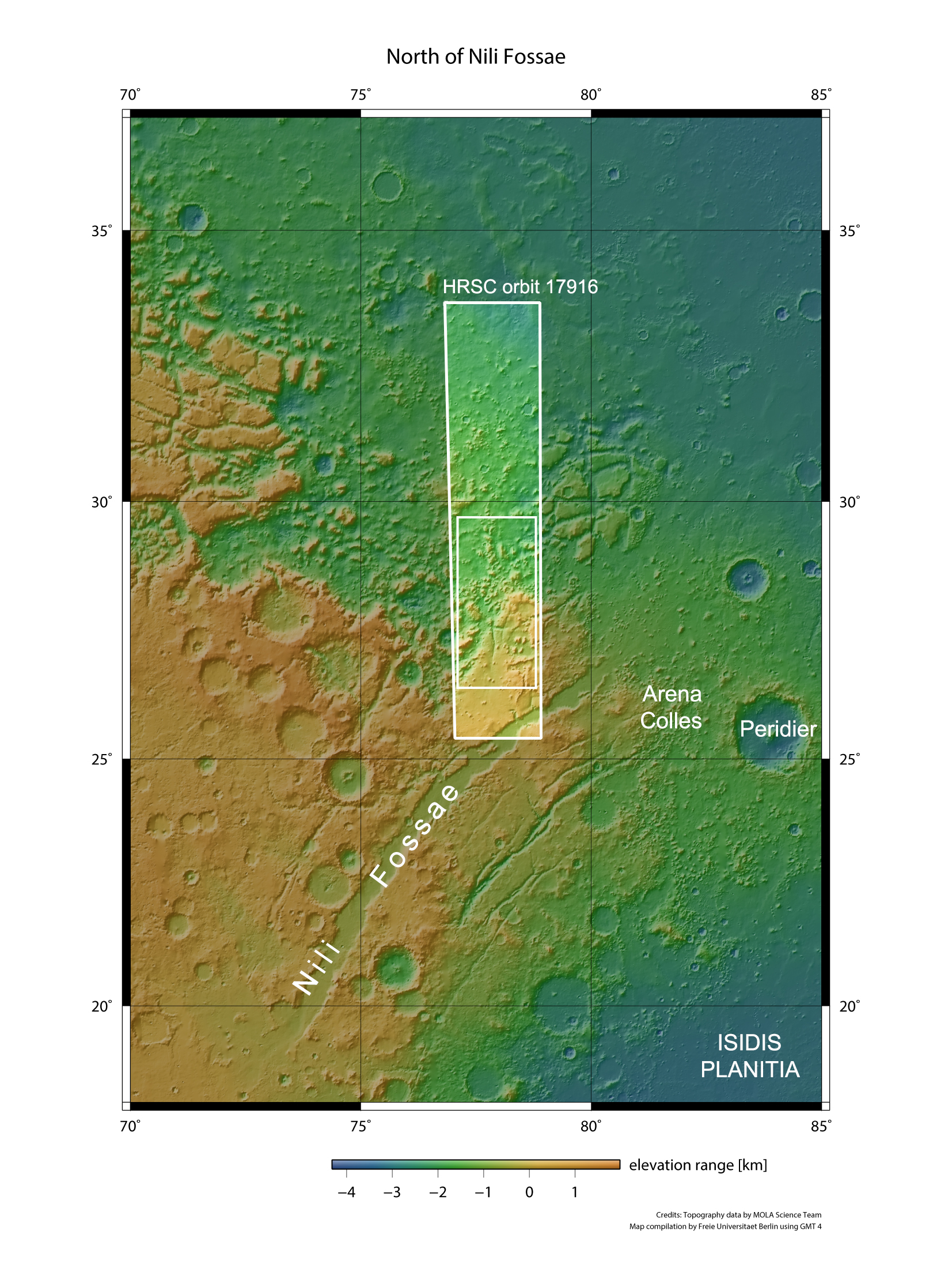
Topographical overview map of Nili Fossae on Mars
Nili Fossae is a 30-kilometre-wide tectonic system of grabens on the boundary between the Martian highlands and the northern lowlands. The transition between these two major topographical Martian landscapes, known as the dichotomy boundary, is particularly typical here: the smooth highland plains form a terrain edge several thousand metres high, breaking away to the north. The foothills are home to some standalone mesas that have survived erosion, while large expanses of hilly terrain stretch out further to the north. DLR’s High Resolution Stereo Camera (HRSC) on board the ESA Mars Express spacecraft surveyed the area on 26 February 2018 from an altitude of around 400 kilometres, during orbit 17,916. Credit: NASA/USGS (MOLA); FU Berlin.
Topographical picture map of the region north of Nili Fossae
The image strips acquired from different angles by the HRSC camera system were used to generate digital terrain models of the Martian surface, containing elevation information for each recorded pixel. The reference level to which the altitude readings refer is an imaginary surface that represents the same gravitational pull as that of sea level on Earth. Known as an equipotential surface, this is shaped like a biaxial ellipsoid and is called the Areoid, a name derived from Ares, the Greek word for Mars. In this image, North is to the right. Credit: ESA/DLR/FU Berlin, CC BY-SA 3.0 IGO.
3D view of the northern part of the Nili Fossae region
So-called anaglyph images can be produced from the nadir channel (oriented vertically onto the surface of Mars) of the HRSC camera system operated by the DLR on board the ESA Mars Express space probe and one of the four oblique-view stereo channels. When viewed with red-blue or red-green glasses, these images give a realistic, three-dimensional view of the landscape. Credit: ESA/DLR/FU Berlin, CC BY-SA 3.0 IGO.
These images, acquired by the High Resolution Stereo Camera (HRSC), operated by the German Aerospace Center (Deutsches Zentrum für Luft- und Raumfahrt; DLR), show a region close to the Nili Fossae. The Nili Fossae are located at the border between the southern highlands and the northern lowlands of Mars. The landscape is characterised by mesas, valleys and numerous low hills, shaped by water-driven erosion processes. The HRSC experiment is on board ESA's Mars Express mission, which has been orbiting Mars since 2003. The images show a hilly landscape scored through by a myriad of furrows. This area lies on what is known as Mars' dichotomy boundary, or sometimes as the highland-lowland boundary. The pronounced dichotomy between the crater-strewn highlands south of the equator and the smooth northern lowlands, is one of Mars' most striking topographical features. In most places, the transition between the two is marked by a steep terrain edge, with numerous inselbergs or outlier mountains at the foothill, which represent the remnants of the highlands and were able to withstand the processes of erosion for a longer period of time. Traces of glacier activity and ice can often be seen along the dichotomy boundary, indicating the presence of ice in the past. The southern region, with its plateau-like rocks (on the left in images 1, 4 and 5), is significantly higher than areas further north (on the right), which mainly consist of smaller mesas and hills. These are interspersed with depressions that formed through erosion processes during the planet’s past. Water and ice transported the rocky material downslope into areas of lower elevation millions of years ago. The narrow valleys bear particularly clear traces of these flow processes, with line-like structures that show where material was transported by water or ice. The elevations in the adjacent northern lowlands are testament to the former level of the terrain and are thought to consist of more resistant material. One process still at play on the Martian surface is the transport of sand and dust by wind. Visible traces of this can be found in the depressions, which are filled with dark material. The dark sand is of volcanic origin and forms wide-ranging expanses of sand and dunes. Clay minerals and carbonates indicate earlier water deposits The Nili Fossae area is particularly interesting to those researching Mars because of its diverse mineralogy. In the course of the planet’s geological development, the minerals of the rocks located here were once increasingly altered due to the effects of the water flowing over the surface, but also by water circulating through fissures and cracks in the rocky crust, presumably warmed by volcanic heat, in the form of hydrothermal solutions. Traces of these minerals transformed by influence of water are found in several places. Instruments for investigating the mineralogical composition of the Martian rock, such as the OMEGA spectrometer on board Mars Express, have discovered substances including clay minerals with water molecules embedded into their crystal structure. The presence of these water-rich minerals allows us to draw conclusions about the conditions under which they formed and the climate of Mars in the past. Moreover, the discoveries in Nili Fossae also include carbonates that occur primarily as limestones (calcium carbonate) or dolomite (calcium magnesium carbonate) on Earth. In parts of Nili Fossae, the CRISM spectrometer on NASA's Mars Reconnaissance Orbiter discovered the magnesium carbonate magnesite, which was probably formed there from olivine, a mineral contained in the volcanic rock.
|
| URL | 查看原文 |
| 来源平台 | German Aerosapce Center |
| 文献类型 | 新闻 |
| 条目标识符 | http://119.78.100.173/C666/handle/2XK7JSWQ/106735 |
| 专题 | 地球科学 |
| 推荐引用方式 GB/T 7714 | admin. The Nili Fossae grabens on Mars. 2018. |
| 条目包含的文件 | 条目无相关文件。 | |||||
| 个性服务 |
| 推荐该条目 |
| 保存到收藏夹 |
| 查看访问统计 |
| 导出为Endnote文件 |
| 谷歌学术 |
| 谷歌学术中相似的文章 |
| [admin]的文章 |
| 百度学术 |
| 百度学术中相似的文章 |
| [admin]的文章 |
| 必应学术 |
| 必应学术中相似的文章 |
| [admin]的文章 |
| 相关权益政策 |
| 暂无数据 |
| 收藏/分享 |
除非特别说明,本系统中所有内容都受版权保护,并保留所有权利。


修改评论