


27 June 2022–Using a method that works backward from a set of observed earthquakes to test seismic models that fit those observations, researchers working in the Delaware Basin were able to determine whether earthquakes in the region since 2017 were caused by oil and gas operations.
The new study published in Seismological Research Letters also indicates whether seismic activity in a specific part or ”block” of the basin, which stretches through West Texas and New Mexico, was caused by hydraulic fracturing or shallow or deep wastewater disposal.
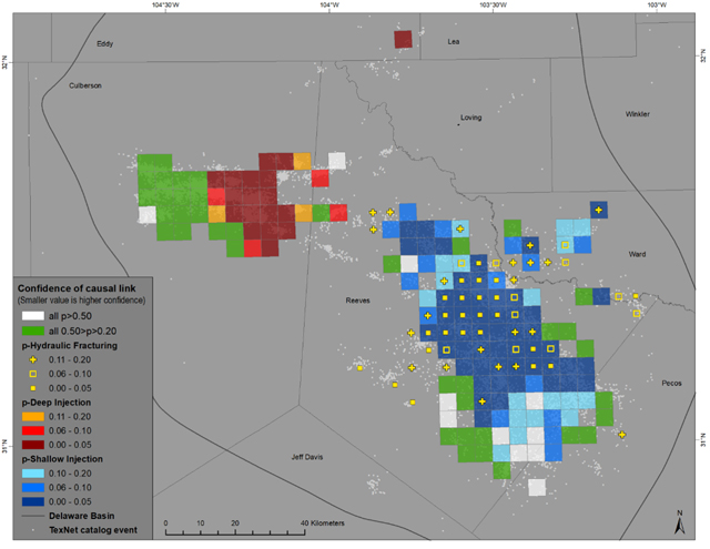
Iason Grigoratos of ETH Zürich, Swiss Seismological Service and colleagues from The University of Texas at Austin calculated how likely one or both of these processes caused seismic activity in each block, finding that at least 68% of the Delaware Basin earthquakes in their study occurred in blocks where oil and gas activities were the likely cause at a 95 percent confidence interval. Grigoratos conducted the study when he was a postdoctoral researcher at UT’s Jackson School of Geosciences.
The SRL study found that hydraulic fracturing was related to more seismic events than was previously suspected, especially within Texas’ Reeves County. However, shallow (roughly one to two kilometers below ground level) wastewater disposal is linked to more earthquakes overall, Grigoratos and colleagues conclude.
Seismicity around the city of Pecos appears to be affected by both hydraulic fracturing and wastewater disposal, the researchers found. Within Texas’ Culberson County, and around the epicenter of the 2020 magnitude 5.0 earthquake in Mentone, Texas, the triggering mechanism appears to be wastewater disposal from deep wells.
Historically, the Delaware Basin has experienced very low seismicity, with only three events above magnitude 4.8 within the past 100 years. But rates of seismicity have been rising gradually in the area since 2009, and further accelerating after 2013. These changes are correlated with an increase in injection volume in both hydraulic fracturing and wastewater disposal wells in the area since 2013.
In their paper, Grigoratos and colleagues “hindcast” the rates of magnitude 1.5 and larger earthquakes that occurred in the Delaware Basin after 2017, using data on hydraulic fracturing or wastewater disposal in the region as the input for their prediction model. They compared these rates to those expected under regular tectonic conditions in the region.
The hindcasting method works well in untangling the potential causes of seismicity in areas where there are multiple types of overlapping oil and gas operations, Grigoratos said.
Looking at changes in well operations over a specific time and space interval can be useful in studying “isolated bursts of seismicity in areas with low well density, as in hydraulic fracturing-induced earthquakes in areas with non-overlapping oil and gas operations,” he noted, but “they are not well suited to deal with wastewater disposal, which often exhibits multiyear delays until the onset of distant and gradual seismicity.”
Hindcasting seismicity rates over time within specific spatial blocks can take into account changes in injection rates as well as how pore pressure changes caused by injection diffuse through underground formations over time and space, he added.
In places where both hydraulic fracturing and wastewater disposal took place, the method does not identify which one might be more important in causing earthquakes, Grigoratos said. “The seismicity in areas affected by both hydraulic fracturing and wastewater disposal is in the ‘shallow’ sedimentary layers and has since 2017 not reached magnitudes above magnitude 3.8,” he explained. “Therefore, as long as the earthquake ruptures do not grow larger and are not migrating very close to exposed assets of critical importance or high vulnerability, restrictions from the regulator do not seem very likely.”
The block map of the region could help oil and gas operators and regulators identify places where future earthquake mitigation or monitoring measures should be put in place, the researchers noted.
修改评论