Global S&T Development Trend Analysis Platform of Resources and Environment
| New tool to drive restoration of historic native oyster reefs | |
| admin | |
| 2022-06-08 | |
| 发布年 | 2022 |
| 语种 | 英语 |
| 国家 | 英国 |
| 领域 | 资源环境 |
| 正文(英文) |
Press release
New tool to drive restoration of historic native oyster reefsA new tool to help increase the native oyster population around the English coast has been launched, the Environment Agency announced today. 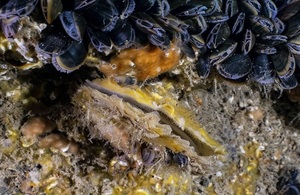
A new tool to help increase the native oyster population around the English coast has been launched, the Environment Agency announced today. Credit: Native oyster, Brighton Pier © Dr Paul Naylor. A new tool to help increase the native oyster population around the English coast has been launched, the Environment Agency announced today (World Oceans Day 8 June). Native oyster populations have decreased by 95% in England since the mid-1800s, mainly due to over-fishing. The aim is to reverse this decline because they bring multiple benefits, including cleansing seawater through filtration and increasing biodiversity and fish abundance. Developed by academics from the University of Exeter and the University of Edinburgh for the Environment Agency, the new map data layer is on the ArcGIS (geographical information service) site and provides information on the location of historic native oyster records and distributions. It will also sit on the Coastal Data Explorer, which is a public web mapping portal managed by the Catchment Based Approach initiative. It can act as a tool to support local authorities, community partnerships and environmental organisations to make the case for native oyster restoration projects, one of the three estuarine and coastal habitats that are the focus of the Restoring Meadows, Marsh and Reef (ReMeMaRe) habitat restoration partnership project. The layer works alongside the Environment Agency’s Native Oyster Restoration Potential maps that highlight areas where oyster restoration could be successful, and the UK & Ireland Native Oyster Network and Environment Agency’s European Native Oyster Habitat Restoration Handbook that provides guidelines on how to restore these valuable habitats. The handbooks and maps aim to counter the huge loss in native oyster reefs over the last two centuries by encouraging and supporting new restoration projects. The map layer was created using data from government, and scientific and maritime bodies, and historic media accounts that mention the use and presence of the native oyster, Ostrea edulis, across England. Environment Agency Estuary and Coast Planning Manager Roger Proudfoot said:
Dr Ruth Thurstan, Project Lead and Senior Lecturer at the University of Exeter said:
Dr Philine Zu Ermgassen, Project Lead and Research Associate at the University of Edinburgh said:
Further details of native oyster restoration efforts can be found through the Native Oyster Restoration Alliance https://noraeurope.eu.
Published 8 June 2022
|
| URL | 查看原文 |
| 来源平台 | UK Environment Agency |
| 文献类型 | 新闻 |
| 条目标识符 | http://119.78.100.173/C666/handle/2XK7JSWQ/349723 |
| 专题 | 资源环境科学 |
| 推荐引用方式 GB/T 7714 | admin. New tool to drive restoration of historic native oyster reefs. 2022. |
| 条目包含的文件 | 条目无相关文件。 | |||||
| 个性服务 |
| 推荐该条目 |
| 保存到收藏夹 |
| 查看访问统计 |
| 导出为Endnote文件 |
| 谷歌学术 |
| 谷歌学术中相似的文章 |
| [admin]的文章 |
| 百度学术 |
| 百度学术中相似的文章 |
| [admin]的文章 |
| 必应学术 |
| 必应学术中相似的文章 |
| [admin]的文章 |
| 相关权益政策 |
| 暂无数据 |
| 收藏/分享 |
除非特别说明,本系统中所有内容都受版权保护,并保留所有权利。


修改评论