Global S&T Development Trend Analysis Platform of Resources and Environment
| Dwindling water levels of Lake Powell seen from space | |
| admin | |
| 2022-04-11 | |
| 发布年 | 2022 |
| 语种 | 英语 |
| 国家 | 欧洲 |
| 领域 | 地球科学 |
| 正文(英文) | After decades of drought, water levels in Lake Powell, the second-largest humanmade reservoir in the United States, have shrunk to its lowest level since it was created more than 50 years ago, threatening millions of people who rely on its water supply. Satellite images allow us to take a closer look at the dwindling water levels of the lake amidst the climate crisis. Straddling the border of southeast Utah and northeast Arizona, Lake Powell is an important reservoir in the Colorado River Basin. The Colorado River, which Lake Powell flows through, was dammed at Glen Canyon in the early 1960s. The lake provides water to approximately 40 million people, irrigates over 2.2 million hectares of land and has the capacity to generate more than 4200 megawatts of hydropower electricity. In mid-March 2022, Lake Powell’s elevation dropped to an astonishing 1074 m above sea level – the lowest the lake has been since it was filled in 1980. This drastic drop in water levels is documented in natural-colour images captured by the Copernicus Sentinel-2 mission. The area pictured below shows the surface area changes of the reservoir near Bullfrog Marina, approximately 90 km north from Glen Canyon Dam, between March 2018 and March 2022. Dry conditions and falling water levels are unmistakable in the image captured on 18 March 2022, compared to the 2018 shoreline outlined in the image in yellow. 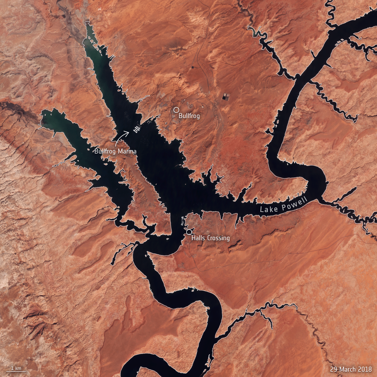
The drop in water levels comes as hotter temperatures and falling water levels left a smaller amount of water flowing through the Colorado River. The peak inflow to Lake Powell occurs in mid-to-late spring, as the winter snow in the Rocky Mountains melts. The line graph shows the drastic drop in average water levels in March since 2000, when Lake Powell was at around 1120 m elevation. The current elevation is just a few meters from what is considered the ‘minimum power pool’ – the level at which Glen Canyon Dam is able to generate hydroelectric power. If Lake Powell drops even more, it could soon hit a ‘deadpool’ where water will likely fail to flow through the dam and onto the nearby Lake Mead.
According to a report compiled by the US Geological Survey in cooperation with the Bureau of Reclamation, Lake Powell’s storage capacity has lost nearly 7% of its potential storage capacity from 1963 to 2018, when the diversion tunnels of Glen Canyon Dam closed and the reservoir began to fill. The capacity of the reservoir is said to be shrinking because of sediments transported by the Colorado and San Juan Rivers. These sediments settle at the bottom of the reservoir and decrease the total amount of water the reservoir can hold. Climate change is expected to make droughts more severe in the future. According to the National Oceanic and Atmospheric Administration (NOAA) Spring Outlook for the US, nearly 60% of the continental US is experiencing drought. These conditions are likely to continue across more than half of the continental United States through at least June, straining water supplies and increasing the risk of wildfires. While these conditions are not new, the agency expects them to potentially worsen in the coming months. |
| URL | 查看原文 |
| 来源平台 | European Space Agency |
| 文献类型 | 新闻 |
| 条目标识符 | http://119.78.100.173/C666/handle/2XK7JSWQ/349041 |
| 专题 | 地球科学 |
| 推荐引用方式 GB/T 7714 | admin. Dwindling water levels of Lake Powell seen from space. 2022. |
| 条目包含的文件 | 条目无相关文件。 | |||||
| 个性服务 |
| 推荐该条目 |
| 保存到收藏夹 |
| 查看访问统计 |
| 导出为Endnote文件 |
| 谷歌学术 |
| 谷歌学术中相似的文章 |
| [admin]的文章 |
| 百度学术 |
| 百度学术中相似的文章 |
| [admin]的文章 |
| 必应学术 |
| 必应学术中相似的文章 |
| [admin]的文章 |
| 相关权益政策 |
| 暂无数据 |
| 收藏/分享 |
除非特别说明,本系统中所有内容都受版权保护,并保留所有权利。


修改评论