Global S&T Development Trend Analysis Platform of Resources and Environment
| A New Method Using Image Classification AI to Predict Potential Natural Vegetation | |
| admin | |
| 2022-04-18 | |
| 发布年 | 2022 |
| 语种 | 英语 |
| 国家 | 日本 |
| 领域 | 资源环境 |
| 正文(英文) |
April 18, 2022
JAMSTEC KYOTO UNIVERSITY A New Method Using Image Classification AI to Predict Potential Natural Vegetation1. Key Points
2. OverviewScientific Researcher Hisashi SATO of the Institute of Arctic Climate and Environment Research (IACE), Research Institute for Global Change (RIGC), Japan Agency for Marine-Earth Science and Technology (JAMSTEC), and Assoc. Prof. Takeshi ISE of Kyoto University’s Field Science Education and Research Center jointly developed a new method using an image classification AI (*1) to estimate potential natural vegetation corresponding to given climates (*2). This is the first application of image classification AI to reconstruct potential natural vegetation, and it offers a convenient and practical means to predict changes in vegetation distribution accompanying climate change. In this method, the image classification AI is trained to extract features of various types of potential natural vegetation based on seasonal change patterns represented in images. The trained AI was able to reproduce the current distribution of potential natural vegetation with better precision than pre-existing methods. Then, the trained AI was applied to climatic scenarios at the end of the 21st century, predicting a significant shift in global vegetation distributions such as (1) decreased forest density in the southern part of the Amazon basin, (2) expansion of temperate forests on the North American and Eurasian continents, and (3) a shift in the distribution of boreal forests towards higher latitudes and altitudes. Although these trends are qualitatively consistent with previous research works, improvements in quantitative reliability are expected. Since this method is simply an application of image classification AI, it demands much less technical skill and computer resources. Therefore, this method could also be applied to building empirical models of other climate-driven phenomena such as cropping systems and the spread of vector-borne diseases and hence has the potential to be a de facto standard for building empirical models across a range of research and application fields. This study was published in Geoscientific Model Development on April 18 (Japan time).
This study was funded by the Ministry of Education, Culture, Sports, Science and Technology’s Arctic Challenge for Sustainability II (ArCS II) (JPMXD1420318865) and the Japan Society for the Promotion of Science’s Grants-in-Aid for Scientific Research (18H03357). 【Supplemental information】
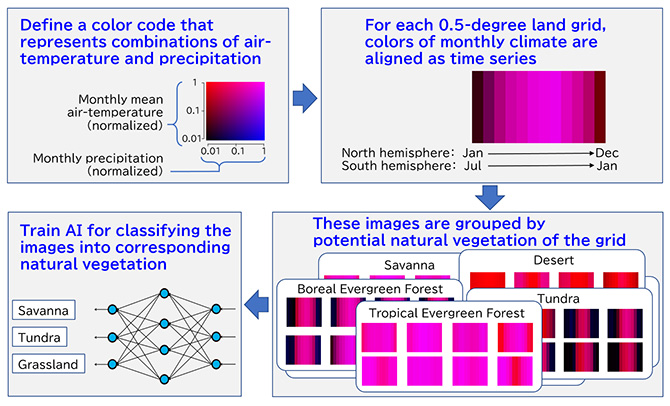
Fig.1 Overview of the method 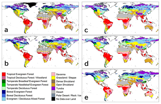
Fig.2 Distributions of potential natural vegetation 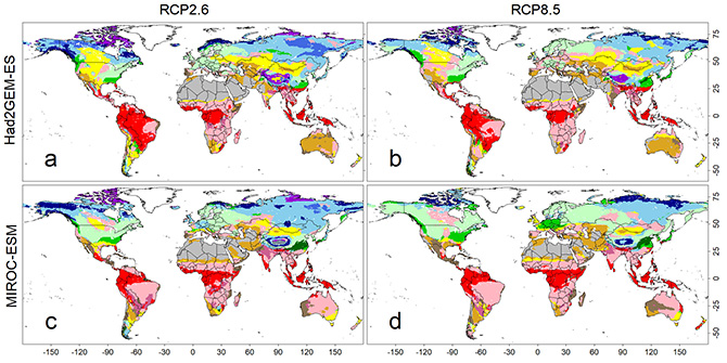
Fig.3 Predicted maps of potential natural vegetation under climatic scenarios from 2091 to 2100. Four sets of forecasted climatic conditions were derived from combinations of two climate models (i.e., Had2GEM-ES and MIROC-ESM) and two RCP scenarios (i.e., RCP2.6 and RCP8.5). Color definitions are available in Fig. 2. Contacts:
|
| URL | 查看原文 |
| 来源平台 | Japan Agency for Marine-Earth Science and Technology |
| 文献类型 | 新闻 |
| 条目标识符 | http://119.78.100.173/C666/handle/2XK7JSWQ/348929 |
| 专题 | 资源环境科学 |
| 推荐引用方式 GB/T 7714 | admin. A New Method Using Image Classification AI to Predict Potential Natural Vegetation. 2022. |
| 条目包含的文件 | 条目无相关文件。 | |||||
| 个性服务 |
| 推荐该条目 |
| 保存到收藏夹 |
| 查看访问统计 |
| 导出为Endnote文件 |
| 谷歌学术 |
| 谷歌学术中相似的文章 |
| [admin]的文章 |
| 百度学术 |
| 百度学术中相似的文章 |
| [admin]的文章 |
| 必应学术 |
| 必应学术中相似的文章 |
| [admin]的文章 |
| 相关权益政策 |
| 暂无数据 |
| 收藏/分享 |
除非特别说明,本系统中所有内容都受版权保护,并保留所有权利。


修改评论