Global S&T Development Trend Analysis Platform of Resources and Environment
| Environment Agency completes £3 million upgrade to reservoir flood mapping | |
| admin | |
| 2021-11-09 | |
| 发布年 | 2021 |
| 语种 | 英语 |
| 国家 | 英国 |
| 领域 | 资源环境 |
| 正文(英文) |
News story
Environment Agency completes £3 million upgrade to reservoir flood mappingNew upgraded flood maps for all reservoirs in England provide a more accurate picture of flood risk 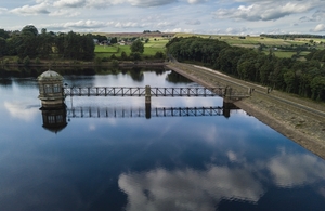
The Environment Agency has released new upgraded flood maps for all reservoirs in England to provide a more accurate picture of flood risk in the very unlikely event of a reservoir failure. The £3 million project has reviewed, updated and improved the reservoir flood maps for 1,865 large raised reservoirs in England. The new maps, which can be viewed on the ‘Check Your Long Term Flood Risk’ page and the Defra Data Services Platform, have made use of the most up-to-date ground level information, new modelling techniques and improved knowledge of how quickly water would flow from a reservoir failure. They are primarily for use by Civil Contingency Responders, such as the emergency services, local authorities and the Environment Agency, helping them to put in place plans for warning and evacuation. John Russon, FCRM Director at the Environment Agency said:
For the first time the maps show the maximum flood extent both in the case of ‘dry-day’, where reservoir flooding took place with river levels at normal levels and a ‘wet-day’, where reservoir flooding takes place alongside wider river flooding. Ian Scholefield from United Utilities said:
The new maps will also help the undertakers of large raised reservoirs prepare on-site flood plans, which are now required to assure public safety and prepare reservoir undertakers for potential reservoir failure emergencies.
Published 9 November 2021
|
| URL | 查看原文 |
| 来源平台 | UK Environment Agency |
| 文献类型 | 新闻 |
| 条目标识符 | http://119.78.100.173/C666/handle/2XK7JSWQ/340707 |
| 专题 | 资源环境科学 |
| 推荐引用方式 GB/T 7714 | admin. Environment Agency completes £3 million upgrade to reservoir flood mapping. 2021. |
| 条目包含的文件 | 条目无相关文件。 | |||||
| 个性服务 |
| 推荐该条目 |
| 保存到收藏夹 |
| 查看访问统计 |
| 导出为Endnote文件 |
| 谷歌学术 |
| 谷歌学术中相似的文章 |
| [admin]的文章 |
| 百度学术 |
| 百度学术中相似的文章 |
| [admin]的文章 |
| 必应学术 |
| 必应学术中相似的文章 |
| [admin]的文章 |
| 相关权益政策 |
| 暂无数据 |
| 收藏/分享 |
除非特别说明,本系统中所有内容都受版权保护,并保留所有权利。


修改评论