


25 August 2021–The Codex Telleriano Remensis, created in the 16th century in Mexico, depicts earthquakes in pictograms that are the first written evidence of earthquakes in the Americas in pre-Hispanic times, according to a pair of researchers who have systematically studied the country’s historical earthquakes.
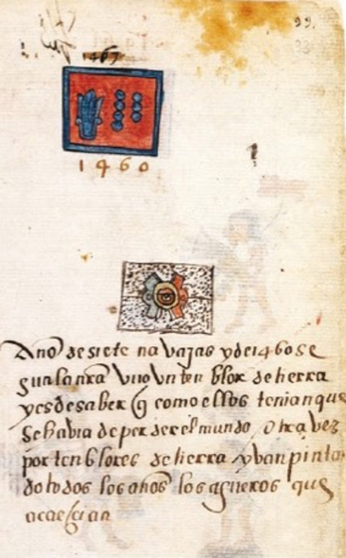
Gerardo Suárez of the Universidad Nacional Autónoma de México and Virginia García-Acosta of the Centro de Investigaciones y Estudios Superiores en Antropología Social studied pictograms reporting 12 earthquakes in the Telleriano-Remensis, occurring between 1460 and 1542.
The pictograms offer little information on the location, size or damage caused by the earthquakes, the authors note in the journal Seismological Research Letters. But along with other historical accounts found in annals written after the Spanish conquest, they extend the region’s seismic history back into the 15th century.
“It is not surprising that pre Hispanic records exist describing earthquakes for two reasons,” said Suárez. “Earthquakes are frequent in this country and, secondly, earthquakes had a profound meaning in the cosmological view of the original inhabitants of what is now Mexico.”
Mesoamerican civilizations viewed the universe as cyclical, with successive eras or “suns” destroyed by floods, wind, fire and other phenomena before the appearance of a new sun. The current and fifth “sun, “according to this view, will be destroyed by earthquakes.
Suárez and García-Acosta began studying historical earthquakes in Mexico after the devastating magnitude 8.0 Mexico City earthquake in 1985, eventually publishing their findings in the book Los sismos en la historia de México. “However, we had not tackled the pictographic representation of earthquakes,” said Suárez. “We recently embarked on a more detailed study of this pictographic representation and other texts written immediately after the Spanish conquest.”
Codex writing, a pre-Hispanic system of symbols and colors, was done by trained specialists called tlacuilos (in the original Nahuatl language, “those who write painting”). While many codices were burned as pagan objects after the Spanish conquest, some survived and the pictographic style was used in new codices up into the 18th century.
The Codex Telleriano-Remensis is written on European paper, with explanations or “glosses” written in Latin, Spanish and sometimes Italian by later commentators alongside the symbols.
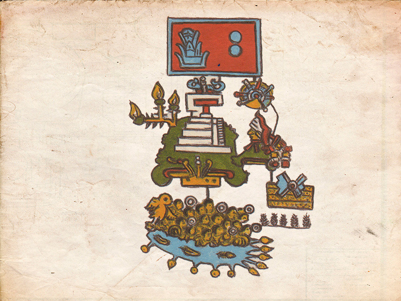
Earthquakes, called tlalollin in the Nahuatl language, are represented by two signs: ollin (movement) and tlalli (earth). Ollin is a glyph consisting of four helices and a central eye or circle. Tlalli is a glyph consisting of one or several layers filled with dots and different colors.
In the Telleriano-Remensis, there are other modifications of the earthquake glyphs, but their meanings are not clear to scholars. “However, the consensus is that the various representations probably do have a meaning,” Suárez said. “Drawing codices was a strict discipline not open to artistic whims of the people trained to do it, the tlacuilos. We are hopeful that in the future an unknown codex or document may appear that may enlighten us in this respect.”
Suárez and García-Acosta note that other annals offer information that complements the codex earthquake drawings, perhaps filling in more details about the impacts and locations of specific earthquakes. For example, a historical account by the Franciscan friar Juan de Torquemada describes a 1496 earthquake that shook three mountains in “Xochitepec province, along the coast” and caused landslides in an area inhabited by the Yope people.
The site is within the Guerrero seismic gap, a region of relative seismic quiet along the subduction zone in southern Mexico. The historical descriptions suggest that the 1496 earthquake might have been a very large earthquake of magnitude 8.0 or larger within the gap. There have been no recorded earthquakes of that magnitude in the gap since 1845.
The historical evidence “really does not change our view of the seismic potential of that region in southern Mexico,” Suárez explained. “It simply adds additional evidence that great earthquakes have occurred in this segment of the subduction zone before, and the absence of these major earthquakes for several years should not be considered as though this region is aseismic.”
The researchers plan to study other codices that are not as well-known as the Telleriano-Remensis, but have so far been unable to access the libraries that hold them due to COVID-19 restrictions.
修改评论