Global S&T Development Trend Analysis Platform of Resources and Environment
| Earth from Space: Lake Mar Chiquita | |
| admin | |
| 2021-06-25 | |
| 发布年 | 2021 |
| 语种 | 英语 |
| 国家 | 欧洲 |
| 领域 | 地球科学 |
| 正文(英文) | The Copernicus Sentinel-1 mission takes us over Lake Mar Chiquita – an endorheic salt lake in the northeast province of Córdoba, Argentina. Click on the image to explore it in its full resolution and learn about the features in this stunning landscape. 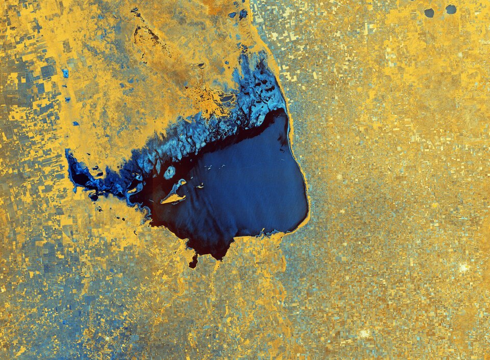
Lake Mar Chiquita, around 70 km long and 24 km wide, is fed primarily by the Primero and Segundo rivers from the southwest and from the Dulce river from the north. While these rivers flow into the lake, there isn’t a natural outflow of water so it only loses water by evaporation, hence Lake Mar Chiquita being described as an endorheic lake. The lake’s surface area, as well as its salinity, varies considerably (ranging between 2000 and 6000 sq km), although it is slowly diminishing in size owing to evaporation. Several small islands lie in the lake, the most important of which is El Médano. Vast expanses of saline marshes can be seen on the lake’s northern shore. The lake has been designated as a Ramsar Site of International Importance, and is considered one of the most important wetlands in Argentina owing to its rich biodiversity. Over 25 species of fish are known to breed in Lake Mar Chiquita, with fishing and livestock being the principal land uses. The colours of this week’s image come from the combination of two polarisations from the Sentinel-1 radar mission, which have been converted into a single image. As radar images provide data in a different way than a normal optical camera, the images are usually black and white when they are received. By using a technology that aligns the radar beams sent and received by the instrument in one orientation – either vertically or horizontally – the resulting data can be processed in a way that produces coloured images such as the one featured here. This technique allows scientists to better analyse Earth’s surface. Shades of blue in the image show us where the differences between the two polarisations are higher, for example the saline marshes in the lake’s north, whereas the crops and agricultural fields in the surrounding area appear yellow, indicating fewer differences between polarisations. Fields, such as those visible in the bottom-left corner of the image, appear blue most likely because they are wetter. Several villages, including San Francisco and Rafaela, are identifiable in white in the bottom-right of the image. This image, acquired on 17 November 2020, is also featured on the Earth from Space video programme. 
Earth from Space: Lake Mar Chiquita
Access the video |
| URL | 查看原文 |
| 来源平台 | European Space Agency |
| 文献类型 | 新闻 |
| 条目标识符 | http://119.78.100.173/C666/handle/2XK7JSWQ/332211 |
| 专题 | 地球科学 |
| 推荐引用方式 GB/T 7714 | admin. Earth from Space: Lake Mar Chiquita. 2021. |
| 条目包含的文件 | 条目无相关文件。 | |||||
| 个性服务 |
| 推荐该条目 |
| 保存到收藏夹 |
| 查看访问统计 |
| 导出为Endnote文件 |
| 谷歌学术 |
| 谷歌学术中相似的文章 |
| [admin]的文章 |
| 百度学术 |
| 百度学术中相似的文章 |
| [admin]的文章 |
| 必应学术 |
| 必应学术中相似的文章 |
| [admin]的文章 |
| 相关权益政策 |
| 暂无数据 |
| 收藏/分享 |
除非特别说明,本系统中所有内容都受版权保护,并保留所有权利。


修改评论