Global S&T Development Trend Analysis Platform of Resources and Environment
| Monitoring European air traffic with Earth observation | |
| admin | |
| 2020-12-07 | |
| 发布年 | 2020 |
| 语种 | 英语 |
| 国家 | 欧洲 |
| 领域 | 地球科学 |
| 正文(英文) | In early 2020, ESA launched a contest asking the general public to submit ideas on how Earth observation data can help monitor the impacts of the COVID-19 pandemic. Now, one of the winning ideas has been integrated into the ‘Rapid Action on COVID-19 with Earth observation’ dashboard – a joint initiative from ESA and the European Commission. This new idea focuses on monitoring air traffic in Europe using imagery from the Copernicus Sentinel-2 mission. The COVID-19 pandemic has had far-reaching consequences on the global aviation industry. As a result of the imposed national restrictions on mobility, passenger numbers were drastically reduced compared to previous years – with several aircraft operators reducing their fleets and relying heavily on government support. 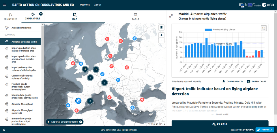
In response to the pandemic, ESA launched a call for proposals asking for innovative ideas that can exploit high-quality Copernicus satellite data to monitor the many effects of coronavirus. The second of the two winning ideas, proposed by a team led by Maurício Pamplona Segundo, uses artificial intelligence (AI), in the form of deep learning algorithms, to detect flying airplanes in images captured by the Copernicus Sentinel-2 mission. Taking advantage of the Euro Data Cube platform, the team assessed 30 of the busiest European airports, including Heathrow Airport, in London, Charles de Gaulle Airport, in Paris, and Frankfurt Airport. The results demonstrated the drastic effect of the pandemic on the aviation industry at a European-level, with reductions in air travel down by up to 90% for most airports during the early months of the pandemic. The indicator, now available in the dashboard, compares the number of flying airplanes on a monthly basis compared to the previous year. Maurício Pamplona Segundo commented, “The results are achieved due to the distinct ‘rainbow pattern’ created by the airplanes that fly at a high-altitude of the aircraft relative to the ground and the slight temporal, or spatial, differences in the spectral bands of the Multi-Spectral Imager camera. “A deep learning model was then trained to detect these patterns in the individual Sentinel-2 images. This kind of detection exploits the unique appearance of high-altitude moving objects visible in Sentinel-2 images.” 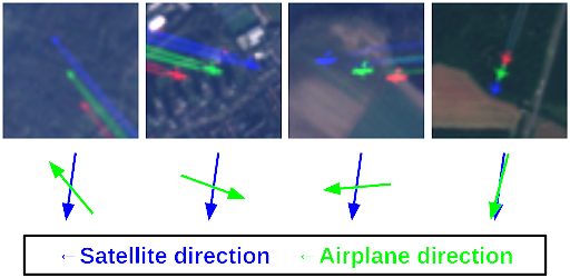
The results were then validated using the real airplane positions and flight statistics available from official sources, and demonstrated the remarkable capability of the detection results. The indicator can now be explored in the dashboard, and is updated on a monthly basis. Earth observation can be used to track different aspects of the impacts of the pandemic on the aviation industry. The ‘Rapid Action on COVID-19 with Earth observation’ dashboard already features an economic indicator that is able to track the number of parked airplanes at different European airports compared to the baseline. Both indicators offer a complementary view on the effects of the pandemic on air traffic in Europe. |
| URL | 查看原文 |
| 来源平台 | European Space Agency |
| 文献类型 | 新闻 |
| 条目标识符 | http://119.78.100.173/C666/handle/2XK7JSWQ/306573 |
| 专题 | 地球科学 |
| 推荐引用方式 GB/T 7714 | admin. Monitoring European air traffic with Earth observation. 2020. |
| 条目包含的文件 | 条目无相关文件。 | |||||
| 个性服务 |
| 推荐该条目 |
| 保存到收藏夹 |
| 查看访问统计 |
| 导出为Endnote文件 |
| 谷歌学术 |
| 谷歌学术中相似的文章 |
| [admin]的文章 |
| 百度学术 |
| 百度学术中相似的文章 |
| [admin]的文章 |
| 必应学术 |
| 必应学术中相似的文章 |
| [admin]的文章 |
| 相关权益政策 |
| 暂无数据 |
| 收藏/分享 |
除非特别说明,本系统中所有内容都受版权保护,并保留所有权利。


修改评论