Global S&T Development Trend Analysis Platform of Resources and Environment
| Climate Change Vulnerability Assessment for Los Angeles County Published | |
| admin | |
| 2020-10-14 | |
| 发布年 | 2020 |
| 语种 | 英语 |
| 国家 | 美国 |
| 领域 | 资源环境 |
| 正文(英文) |  King tide at Malibu Surfrider Beach. Credit: California King Tides Project. Coastal communities are increasingly vulnerable to climate effects, such as sea level rise and coastal erosion. In an effort to provide information to better protect, advance, and manage climate change impacts within local communities, social scientists with NOAA’s National Centers for Coastal Ocean Science (NCCOS) have concluded their latest application of the Integrated Vulnerability Assessment Framework within Los Angeles County, California. This research identified and assessed social, structural, and natural resource vulnerability profiles for three geographies: the entirety of Los Angeles County, a 10-mile coastal band, and urban areas. Researchers developed risk profiles for flooding, erosion, drought, heat, and wildfire within each study area, and then intersected vulnerability with risk in a series of maps. These maps suggest that erosion is tightly interwoven with flooding impacts, wildfire threatens both rural and newly suburban areas, drought risk is likely to impact both rural and urban areas, heat risk is likely to occur further inland, and many areas of high social vulnerability are also at high flood risk. Explore the maps and other key findings in the Los Angeles County Vulnerability Assessment Story Map. 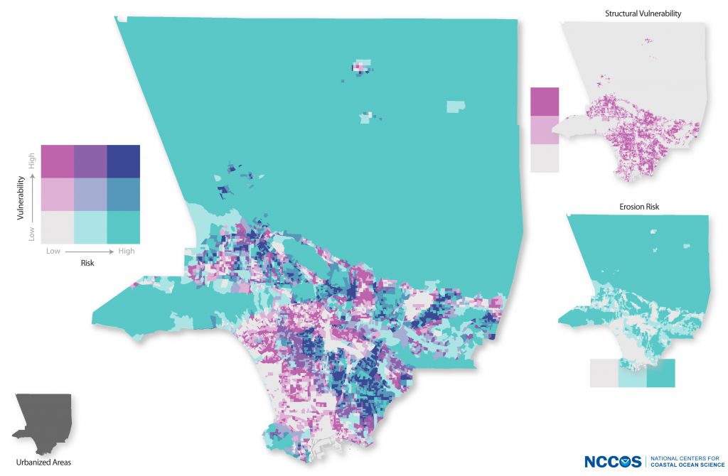 Structural vulnerability intersected with erosion risk for Los Angeles County Following initial assessment, researchers further explored National Flood Insurance Policy claims, access to green and cultural space, and impacts of erosion and flooding on critical infrastructure and blufftop development within the 10-mile coastal band. These analyses found that many high flood risk areas have fewer flood insurance claims, at-risk populations and areas lack green space, cultural resources are at risk of flooding, disaster routes are susceptible to both flooding and erosion impacts, and many areas of new development share high erosion risk. The indicator-driven approach relied upon close partnership with University of Southern California Sea Grant, NOAA’s Office for Coastal Management – West Coast, and local stakeholder input. This is the third application of the NCCOS Framework, building upon previous work done in the Chesapeake Bay. The Framework provides a large scale integration of a combination of various vulnerabilities and risks within each assessment geography. These assessments and underlying data are intended as a holistic first step to identify priority geographies or intersections that warrant future investments of attention and adaptation funds, and can be integrated into various stages of municipal sustainability or climate action plan development and implementation. For more information, contact Chloe.Fleming@noaa.gov or Seann.Regan@noaa.gov. |
| URL | 查看原文 |
| 来源平台 | National Centers for Coastal Ocean Science |
| 文献类型 | 新闻 |
| 条目标识符 | http://119.78.100.173/C666/handle/2XK7JSWQ/299037 |
| 专题 | 资源环境科学 |
| 推荐引用方式 GB/T 7714 | admin. Climate Change Vulnerability Assessment for Los Angeles County Published. 2020. |
| 条目包含的文件 | 条目无相关文件。 | |||||
| 个性服务 |
| 推荐该条目 |
| 保存到收藏夹 |
| 查看访问统计 |
| 导出为Endnote文件 |
| 谷歌学术 |
| 谷歌学术中相似的文章 |
| [admin]的文章 |
| 百度学术 |
| 百度学术中相似的文章 |
| [admin]的文章 |
| 必应学术 |
| 必应学术中相似的文章 |
| [admin]的文章 |
| 相关权益政策 |
| 暂无数据 |
| 收藏/分享 |
除非特别说明,本系统中所有内容都受版权保护,并保留所有权利。


修改评论