Global S&T Development Trend Analysis Platform of Resources and Environment
| GIS Toolbox for Estimating Wave Attenuation by Coastal Marshes Developed by NOAA Funded Study | |
| admin | |
| 2020-10-13 | |
| 发布年 | 2020 |
| 语种 | 英语 |
| 国家 | 美国 |
| 领域 | 资源环境 |
| 正文(英文) | A new free GIS toolbox, that estimates and maps the wave reduction intensity provided by marshes, makes it easier to evaluate marshes for coastal protection. NOAA-funded researchers at Louisiana State University and the University of South Carolina recently published an easy to use, free, GIS-based Wave ATTEnuation Toolbox (WATTE) and an associated article in the journal Environmental Modelling and Software that helps users understand the past, present, and future wave attenuation ability of their coastal marshes. WATTE provides an initial evaluation of the wave attenuation based on marsh habitats that can help determine when restoring or installing a marsh warrants consideration. 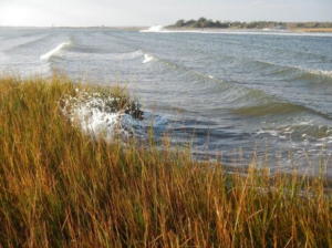 Marsh vegetation helps attenuate wave energy and binds sediments, reducing erosion. Wave processes that can cause damage include wave run-up, induced buoyancy, and induced erosion. Credit NOAA. Waves can damage coastal ecosystems and communities magnified during high water events caused by storms or tides. Scientists expect high water events to worsen under future sea level rise conditions. A principal challenge in determining when natural solutions (aka natural and nature based features) for flood management are a better investment than conventional engineering designs, such as sea walls, lies in the difficulty understanding and quantifying the added benefits provided by natural solutions Engineers better understand conventional designs that can be cheaper to install and inherently more trusted by communities. However, circumstances can warrant more effective natural approaches though the ecosystem benefits and flood risk mitigation benefits, such as wave attenuation, are difficult to assess. WATTE provides users information to gain an understanding of how coastal marshes in their region are reducing wave forces as an added ecosystem service. Traditional modeling tools for wind wave attenuation require advanced expertise to apply, while WATTE is more user friendly. It creates a map of wave height transmission and a line demarking the extent of wave exposure onshore. WATTE supports a variety of applications ranging from ecological and landscape modeling to remote sensing data. Past, present, and future conditions can be analyzed. The present version of WATTE models wave attenuation as a mathematical decay process reducing wave attenuation at a consistent rate over time. A table recommending exponential decay constants for other habitats is derived from previous studies. Three examples of applying WATTE to marsh environments are described for sites in Maine, Mississippi, and Alabama. The approach used by WATTE could also be readily adapted to provide guidance for other habitat types, such as mangroves, seagrass beds, or kelp forests by adjusting the exponential wave decay process for a specific habitat type. WATTE does not aim to replace more advanced approaches such as InVEST, but provides a more user friendly approach utilizing datasets many coastal managers already have at their fingertips. As information and tools that assess ecosystem services continue to be tested and advanced, it will become easier to evaluate more natural approaches to flood risk management in a more comprehensive way. The research described in the paper has been supported by the NCCOS Effects of Sea Level Rise Program. Citations: Foster-Martinez, Madeline and Scott. C. Hagen. 2020. Wave ATTEnuation Toolbox (WATTE). Civil Engineering Datasets, LSU Digital Commons. https://doi.org/10.31390/civil_engineering_data.01 |
| URL | 查看原文 |
| 来源平台 | National Centers for Coastal Ocean Science |
| 文献类型 | 新闻 |
| 条目标识符 | http://119.78.100.173/C666/handle/2XK7JSWQ/298537 |
| 专题 | 资源环境科学 |
| 推荐引用方式 GB/T 7714 | admin. GIS Toolbox for Estimating Wave Attenuation by Coastal Marshes Developed by NOAA Funded Study. 2020. |
| 条目包含的文件 | 条目无相关文件。 | |||||
| 个性服务 |
| 推荐该条目 |
| 保存到收藏夹 |
| 查看访问统计 |
| 导出为Endnote文件 |
| 谷歌学术 |
| 谷歌学术中相似的文章 |
| [admin]的文章 |
| 百度学术 |
| 百度学术中相似的文章 |
| [admin]的文章 |
| 必应学术 |
| 必应学术中相似的文章 |
| [admin]的文章 |
| 相关权益政策 |
| 暂无数据 |
| 收藏/分享 |
除非特别说明,本系统中所有内容都受版权保护,并保留所有权利。


修改评论