Global S&T Development Trend Analysis Platform of Resources and Environment
| OceanReports Tool Now Used in All Phases of Ocean Planning and Permitting | |
| admin | |
| 2020-09-23 | |
| 发布年 | 2020 |
| 语种 | 英语 |
| 国家 | 美国 |
| 领域 | 资源环境 |
| 正文(英文) | 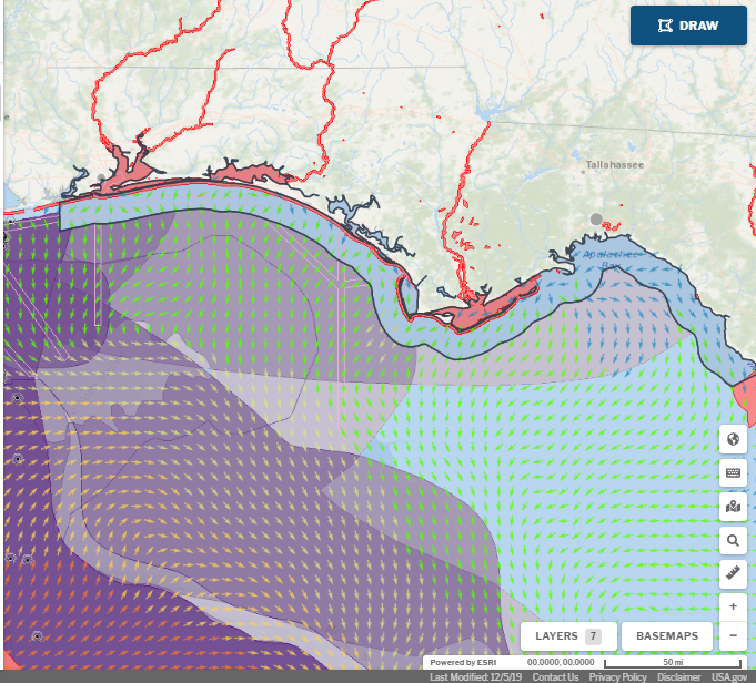 In this Gulf of Mexico example, the OceanReports tool shows data layers for ESA Critical Habitat Designations (red), ports (grey circle), shipping lanes (pink), Bureau of Ocean Energy Management oil and gas leases (purple), and coastal currents (colored arrows). At a quick glance, the user can see environmental conditions and how ocean space is occupied in order to plan for potential future development (arrowheads on the map indicate the direction that currents are moving toward). Credit: MarineCadastre.gov OceanReports, the most comprehensive web-based spatial assessment tool for U.S. ocean waters, is fast becoming popular with businesses and agencies involved in ocean and coastal use, including aquaculture. A new article in MarineCadastre News describes the tool’s ability to quickly and efficiently identify spatial conflicts and areas where oceanographic and biophysical conditions are conducive to cultivated species growth. OceanReports is now being used in all phases of the permitting process from planning and scoping to environmental review. Within seconds, users can explore their ocean neighborhood, and view data about conservation and use, enabling intelligent placement of offshore industries. This web-based interactive tool for ocean mapping and planning was designed for all ocean industries as a source of information for transportation, navigation, renewable energy, natural and protected resources, environmental interactions, and coastal development. Learn more about OceanReports here. |
| URL | 查看原文 |
| 来源平台 | National Centers for Coastal Ocean Science |
| 文献类型 | 新闻 |
| 条目标识符 | http://119.78.100.173/C666/handle/2XK7JSWQ/296060 |
| 专题 | 资源环境科学 |
| 推荐引用方式 GB/T 7714 | admin. OceanReports Tool Now Used in All Phases of Ocean Planning and Permitting. 2020. |
| 条目包含的文件 | 条目无相关文件。 | |||||
| 个性服务 |
| 推荐该条目 |
| 保存到收藏夹 |
| 查看访问统计 |
| 导出为Endnote文件 |
| 谷歌学术 |
| 谷歌学术中相似的文章 |
| [admin]的文章 |
| 百度学术 |
| 百度学术中相似的文章 |
| [admin]的文章 |
| 必应学术 |
| 必应学术中相似的文章 |
| [admin]的文章 |
| 相关权益政策 |
| 暂无数据 |
| 收藏/分享 |
除非特别说明,本系统中所有内容都受版权保护,并保留所有权利。


修改评论