Global S&T Development Trend Analysis Platform of Resources and Environment
| Giant A-68 iceberg three years on | |
| admin | |
| 2020-07-10 | |
| 发布年 | 2020 |
| 语种 | 英语 |
| 国家 | 欧洲 |
| 领域 | 地球科学 |
| 正文(英文) | The colossus iceberg that split from Antarctica’s Larsen C ice shelf on 12 July 2017 is now in the open waters of the South Atlantic near the South Orkney Islands, about 1050 km from its birthplace. Having lost two chunks of ice, this record berg is a little less huge than it once was – and now that it is in rougher waters, it may break up further. When it calved, A-68 was about twice the size of Luxemburg and one of the largest icebergs on record, changing the outline of the Antarctic Peninsula forever. Despite its size, however, it is remarkably thin, just a couple of hundred metres thick. 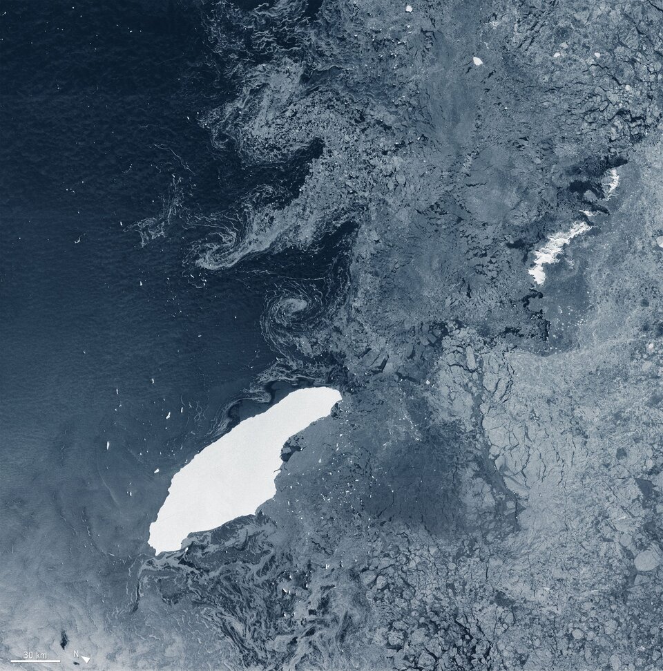
Over the last three years, satellite missions such as Copernicus Sentinel-1 have been used to track the berg as it drifted in the Southern Ocean. For the first two years, it remained close to its parent ice sheet, impeded by sea ice. However, it lost a chunk of ice almost immediately after being calved, resulting in it being renamed A-68A, and its offspring became A-68B. More recently, in April 2020, A-68A lost another chunk: A-68C. Rather unromantically, Antarctic icebergs are named from the Antarctic quadrant in which they were originally sighted, then a sequential number, then, if the iceberg breaks, a sequential letter. Although A-68A is a relatively thin iceberg, it has held together reasonably well, but satellites will be key to monitoring how it changes in open waters. Captured by the Copernicus Sentinel-1 radar mission, the image above shows the berg on 5 July 2020, a few days before its third birthday. Satellites carrying radar continue to deliver images regardless of the dark and bad weather, which is indispensable when monitoring the remote polar regions which are shrouded in darkness during the winter months. 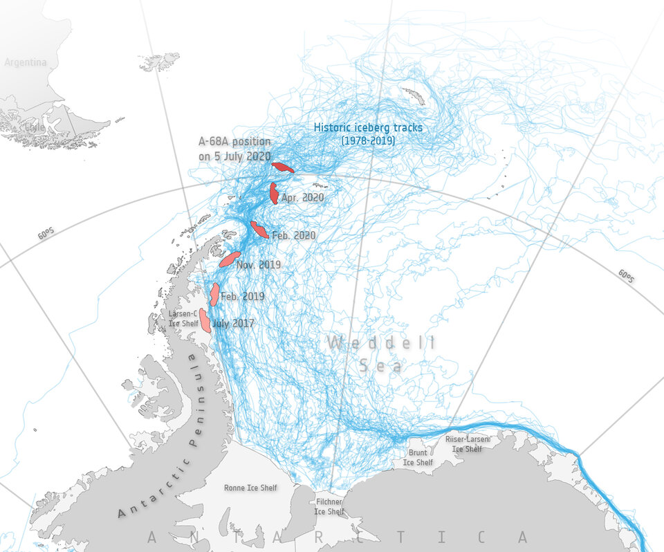
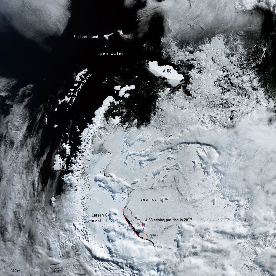
The map shows the different positions of A-68A during its three-year journey. The map not only highlights how long it remained close to the Larsen C ice sheet, but how, over the last year or so, its pace of drift has increased considerably. The map also includes historic iceberg tracks, based on data from a number of satellites including ESA’s ERS-1 and ERS-2, and shows that A-68A is following this well-trodden path. The wider-view image below from the Copernicus Sentinel-3 mission shows A-68A’s position in February 2020. |
| URL | 查看原文 |
| 来源平台 | European Space Agency |
| 文献类型 | 新闻 |
| 条目标识符 | http://119.78.100.173/C666/handle/2XK7JSWQ/282964 |
| 专题 | 地球科学 |
| 推荐引用方式 GB/T 7714 | admin. Giant A-68 iceberg three years on. 2020. |
| 条目包含的文件 | 条目无相关文件。 | |||||
| 个性服务 |
| 推荐该条目 |
| 保存到收藏夹 |
| 查看访问统计 |
| 导出为Endnote文件 |
| 谷歌学术 |
| 谷歌学术中相似的文章 |
| [admin]的文章 |
| 百度学术 |
| 百度学术中相似的文章 |
| [admin]的文章 |
| 必应学术 |
| 必应学术中相似的文章 |
| [admin]的文章 |
| 相关权益政策 |
| 暂无数据 |
| 收藏/分享 |
除非特别说明,本系统中所有内容都受版权保护,并保留所有权利。


修改评论