Global S&T Development Trend Analysis Platform of Resources and Environment
| Blending Satellite Imagery is Both ‘Science and Art’ to Maximize Information Delivery | |
| admin | |
| 2020-04-06 | |
| 发布年 | 2020 |
| 语种 | 英语 |
| 国家 | 美国 |
| 领域 | 气候变化 |
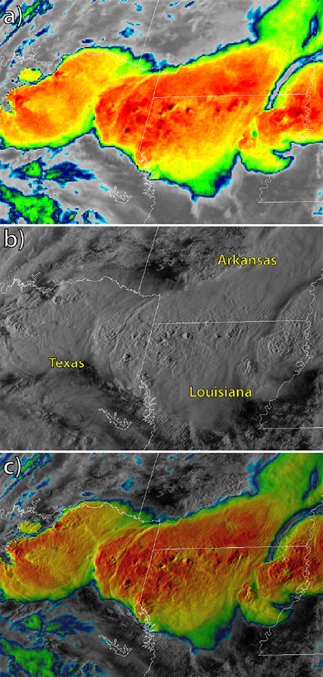
| 正文(英文) | Monitoring the atmosphere by satellite has come a long, long way technologically since TIROS sent back its first snapshots of Earth in 1960. Along with marked advances in spectral, spatial, temporal, and radiometric resolution of state-of-the-art instrumentation, however, come copious volumes of new data as well as unique challenges with how to view it all. We as users are hardly up to the task alone — there’s insufficient time, especially for operational forecasters. The solution: blended imagery. In short, the seamless display of multivariate atmospheric information gleaned from today’s advanced satellites. Value-added imagery from NOAA’s GOES-R satellite series, for example, isn’t just useful, but rather at its best it’s “a balance of science and art,” report the authors of a new paper in the Journal of Atmospheric and Oceanic Technology. Such multidimensional blending of key weather parameters into visually intuitive products maximizes the information available to users. To illustrate this, the author’s applied the blending technique to new GOES-16’s GEOCOLOR imagery. Below is an example of a “sandwich product” in which (a) color-enhanced infrared imagery with a transparency of 70% is superimposed upon (b) visible reflectance imagery of thunderstorms over Texas, Louisiana, and Arkansas at 2319 UTC April 6, 2018, to dynamically (c) blend the images.
This “partial transparency” blending technique highlights the overshooting cloud tops in the convection, enabling forecasters to pinpoint the most intense cells. It’s just one of a number of methods the paper highlights to simultaneously display satellite information and thereby present valuable insight. The technique, the authors conclude, blurs the line between qualitative imagery users want and quantitative products they need. “To the trained human analyst, capable of drawing context from such value-added imagery, combining the best of both worlds provides a powerful new paradigm for working with the new generation of information-rich satellites.” |
| URL | 查看原文 |
| 来源平台 | American Meteorological Society |
| 文献类型 | 新闻 |
| 条目标识符 | http://119.78.100.173/C666/handle/2XK7JSWQ/232590 |
| 专题 | 气候变化 |
| 推荐引用方式 GB/T 7714 | admin. Blending Satellite Imagery is Both ‘Science and Art’ to Maximize Information Delivery. 2020. |
| 条目包含的文件 | 条目无相关文件。 | |||||
| 个性服务 |
| 推荐该条目 |
| 保存到收藏夹 |
| 查看访问统计 |
| 导出为Endnote文件 |
| 谷歌学术 |
| 谷歌学术中相似的文章 |
| [admin]的文章 |
| 百度学术 |
| 百度学术中相似的文章 |
| [admin]的文章 |
| 必应学术 |
| 必应学术中相似的文章 |
| [admin]的文章 |
| 相关权益政策 |
| 暂无数据 |
| 收藏/分享 |
除非特别说明,本系统中所有内容都受版权保护,并保留所有权利。


修改评论