Global S&T Development Trend Analysis Platform of Resources and Environment
| Interactive Outreach Tool Illustrates How Wastewater Travels Through Pittsburgh | |
| admin | |
| 2020-03-13 | |
| 发布年 | 2020 |
| 语种 | 英语 |
| 国家 | 国际 |
| 领域 | 资源环境 |
| 正文(英文) | The Allegheny County Sanitary Authority (ALCOSAN; Pittsburgh, Pa.) has partnered with environmental nonprofit 3 Rivers Wet Weather (Pittsburgh) and geospatial technology company CivicMapper (Pittsburgh) to map the wastewater collection systems in their service area. An interactive map, called “Flush-It!,” enables citizens to follow wastewater flow from any Pittsburgh address — including their homes and businesses — to ALCOSAN’s principal water resource recovery facility (WRRF) in the city’s North Side. Following the FlushThe map uses colored lines to track wastewater’s journey from toilets and drains through pipes before it eventually reaches the ALCOSAN WRRF. The interactive tool reveals how far wastewater travels through the city as well as how long it takes. For instance, a flush from Heinz Field, home of the Pittsburgh Steelers, travels approximately 21,000 ft (4 mi) through the collection system network before reaching the WRRF, taking anywhere between 3 to 6 hours to complete its journey during typical dry-weather operations. However, language from the modeling experts behind the tool reminds users that distance alone does not determine travel speed. According to ALCOSAN, Flush-It! assumes a typical flow rate between 1 and 2 ft/s. However, if the region experiences precipitation, inflow and infiltration can easily overwhelm older parts of the city’s collection system network. During wet weather, inflow and infiltration can multiply the amount of water conveyed through the combined-sewer-system segments of Pittsburgh’s network by as much as 30 times compared to dry-weather conditions, 3 Rivers Wet Weather describes, greatly slowing down travel speeds. “It’s really interesting to see how that path can cross over rivers multiple times,” Emily Mercurio, CivicMapper CEO, told National Public Radio (NPR) in February. “It really takes a wild ride throughout the region.” Open-Source OutreachTo create the tool, 3 Rivers Wet Weather and CivicMapper combined all municipal sewer data in the ALCOSAN service area, which covers 82 municipalities and other entities. Modelers carefully mapped the direction of sewage flow and created algorithms that calculate travel time from flush to treatment. The code for the tool is open to the public, which was part of the project’s broader goal: use as an educational tool. 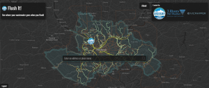 A new map developed by a partnership between a utility, a nonprofit, and a private company enables Pittsburgh residents to track the route wastewater takes from individual buildings to the region’s largest water resource recovery facility. Click here to access the tool. Image courtesy of ALCOSAN/3 Rivers Wet Weather/CivicMapper “The underlying [geographic information system] technology and data utilized by the map is already in place and is used on a daily basis; we merely interfaced with it in a different way to make this little mapping application,” reads a write-up about the tool on the 3 Rivers Wet Weather website. “In addition to showing where your toilet flushes go, this map demonstrates the power of using open data standards and open-source technology designed for the modern web.” Mercurio told NPR that the partnership behind the tool wants to help the public better understand the consequences of what they flush. Their hope is that citizens become more aware of where local collection system infrastructure is located, and that when they flush, it goes somewhere — that “it has a life after it leaves the house,” Mercurio said. ALCOSAN has spent more than $800,000 on marketing efforts, including the interactive map, as part of a $2 billion plan to clean up chronic sewage overflows into the region’s waterways. Experiment with the “Flush-It!” tool at the CivicMapper website. — Will Fowler, WEF Highlights  |
| URL | 查看原文 |
| 来源平台 | Water Environment Federation |
| 文献类型 | 新闻 |
| 条目标识符 | http://119.78.100.173/C666/handle/2XK7JSWQ/229257 |
| 专题 | 资源环境科学 |
| 推荐引用方式 GB/T 7714 | admin. Interactive Outreach Tool Illustrates How Wastewater Travels Through Pittsburgh. 2020. |
| 条目包含的文件 | 条目无相关文件。 | |||||
| 个性服务 |
| 推荐该条目 |
| 保存到收藏夹 |
| 查看访问统计 |
| 导出为Endnote文件 |
| 谷歌学术 |
| 谷歌学术中相似的文章 |
| [admin]的文章 |
| 百度学术 |
| 百度学术中相似的文章 |
| [admin]的文章 |
| 必应学术 |
| 必应学术中相似的文章 |
| [admin]的文章 |
| 相关权益政策 |
| 暂无数据 |
| 收藏/分享 |
除非特别说明,本系统中所有内容都受版权保护,并保留所有权利。


修改评论