Global S&T Development Trend Analysis Platform of Resources and Environment
| Seeking Expressions of Interest for Global Navigation Satellite System (GNSS) Ground Station Site Hosts | |||||||||||||||||||||||||||||||||||||||||||||||||||||||||||||||||||||||||||||||||||||||||||||
| admin | |||||||||||||||||||||||||||||||||||||||||||||||||||||||||||||||||||||||||||||||||||||||||||||
| 2019-09-05 | |||||||||||||||||||||||||||||||||||||||||||||||||||||||||||||||||||||||||||||||||||||||||||||
| 发布年 | 2019 | ||||||||||||||||||||||||||||||||||||||||||||||||||||||||||||||||||||||||||||||||||||||||||||
| 语种 | 英语 | ||||||||||||||||||||||||||||||||||||||||||||||||||||||||||||||||||||||||||||||||||||||||||||
| 国家 | 澳大利亚 | ||||||||||||||||||||||||||||||||||||||||||||||||||||||||||||||||||||||||||||||||||||||||||||
| 领域 | 地球科学 | ||||||||||||||||||||||||||||||||||||||||||||||||||||||||||||||||||||||||||||||||||||||||||||
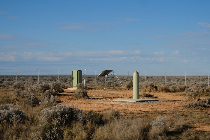
| 正文(英文) |  Positioning Australia is the Geoscience Australia program delivering a national capability of accurate and reliable positioning anywhere, anytime. A precise positioning capability will deliver increased productivity, improve community safety, allow for potential innovative technologies and accelerate economic growth. In order to ensure that more accurate positioning information is widely available to all Australians, Geoscience Australia is establishing a land based infrastructure network of 200 Global Navigation Satellite System (GNSS) ground stations across the country. This includes upgrading 130 existing sites and establishing 70 new ground stations in specific locations. This will improve and densify the existing network and establish a grid like network of GNSS ground stations at a separation of approximately 200 – 300km across all of Australia. Geoscience Australia is seeking expressions of interest from landowners to host new Global Navigation Satellite System (GNSS) ground station sites on their land. If your land is within the predetermined areas and meets the technical requirements, Geoscience Australia would like to discuss the opportunity to establish a new GNSS ground station site on your property. Site occupancy will be secured via a formal arrangement, such as a long term lease or licence agreement registered against the land title. Nominally, a peppercorn rental arrangement will be negotiated for each site in line with the program objectives to provide highly available, free and open access to positioning data and products across the country. What is a Global Navigation Satellite System (GNSS) ground station?A GNSS ground station records and verifies signals from over 100 GNSS satellites. This data is streamed to a processing centre where it is used to generate correction models that are broadcast to users across the country. A GNSS ground station foot print is approximately 40m x 40m and consists of:
The site may also include:
Typical GNSS ground station. Image: Nullabor site, SA LocationsIn order to densify the network of existing GNSS ground stations and ensure adequate coverage and redundancy over the whole of Australia, new site location areas have been predetermined based on a grid of stations at a separation of 200 – 300km. New GNSS ground stations sites must be within 50km of the following locations.
Map of proposed new GNSS site localities [PDF 668KB] Technical requirementsA GNSS ground station must meet specific technical requirements including:
How to lodge an expression of interest (EOI)If you would like to assist us in realising this important national capability by hosting a new GNSS ground station site, please register you expression of interest by completing the form below. TimeframesIn order to align with the Positioning Australia program new GNSS sites must be identified and assessed before the end of 2019. Expressions of Interest must be registered by COB Monday 13th October 2019. Next stepsAll sites registered through this EIO process will be assessed via a desktop analysis against the technical requirements in the first instance. Sites assessed as suitable will be escalated to field reconnaissance, which will involve GA representatives visiting site to validate the desktop data. Geoscience Australia representatives will be in contact with landowners as possible sites progress through the evaluation process. Should your site be assessed as suitable, GA personnel will further consult with you to progress a formal arrangement for hosting the site on a permanent basis. Note: Geoscience Australia representatives will not access land without appropriate consents, approval and/or permits. Stakeholder engagementGeoscience Australia is committed to respectful, transparent and open engagement with all stakeholders, from negotiating land access arrangements to engaging local contractors. Our Stakeholder Engagement Plan provides the framework for how we interact with stakeholders, including the requirements to notify and advise landowners before accessing land. We are also committed to undertaking field activities and all on site work in a safe and respectful way, in consultation with local communities. We are committed to maintaining good working relationships with our stakeholders, and complying with relevant federal, state and territory legislation. To support this commitment, we have a policy, procedures and guidelines that apply to all our employees and contractors when undertaking work on site. For more information please see Field work information for stakeholders Further information Please do not hesitate to contact us on the details below to discuss this EOI process, the Positioning Australia program or the potential to host a new GNSS ground station on your land.
| ||||||||||||||||||||||||||||||||||||||||||||||||||||||||||||||||||||||||||||||||||||||||||||
| URL | 查看原文 | ||||||||||||||||||||||||||||||||||||||||||||||||||||||||||||||||||||||||||||||||||||||||||||
| 来源平台 | Geoscience Australia | ||||||||||||||||||||||||||||||||||||||||||||||||||||||||||||||||||||||||||||||||||||||||||||
| 文献类型 | 新闻 | ||||||||||||||||||||||||||||||||||||||||||||||||||||||||||||||||||||||||||||||||||||||||||||
| 条目标识符 | http://119.78.100.173/C666/handle/2XK7JSWQ/136013 | ||||||||||||||||||||||||||||||||||||||||||||||||||||||||||||||||||||||||||||||||||||||||||||
| 专题 | 地球科学 | ||||||||||||||||||||||||||||||||||||||||||||||||||||||||||||||||||||||||||||||||||||||||||||
| 推荐引用方式 GB/T 7714 | admin. Seeking Expressions of Interest for Global Navigation Satellite System (GNSS) Ground Station Site Hosts. 2019. |
| 条目包含的文件 | 条目无相关文件。 | |||||
| 个性服务 |
| 推荐该条目 |
| 保存到收藏夹 |
| 查看访问统计 |
| 导出为Endnote文件 |
| 谷歌学术 |
| 谷歌学术中相似的文章 |
| [admin]的文章 |
| 百度学术 |
| 百度学术中相似的文章 |
| [admin]的文章 |
| 必应学术 |
| 必应学术中相似的文章 |
| [admin]的文章 |
| 相关权益政策 |
| 暂无数据 |
| 收藏/分享 |
除非特别说明,本系统中所有内容都受版权保护,并保留所有权利。


修改评论