Global S&T Development Trend Analysis Platform of Resources and Environment
| Tidal glaciers in Greenland – TanDEM-X elevation models show strongest decline in 80 years | |
| admin | |
| 2019-09-13 | |
| 发布年 | 2019 |
| 语种 | 英语 |
| 国家 | 德国 |
| 领域 | 地球科学 |
| 正文(英文) |
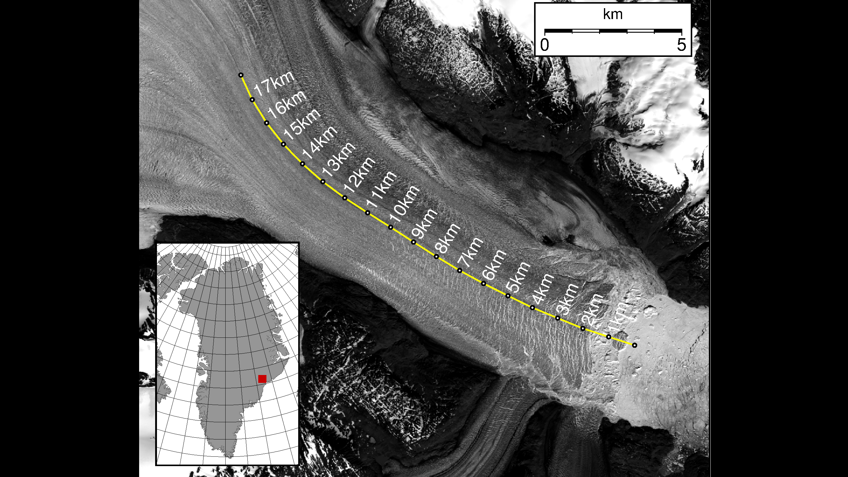
Landsat image
Landsat image (18 June 2016) and map of the Kangerlussuaq glacier in south-eastern Greenland. Credit: DLR (CC-BY 3.0).
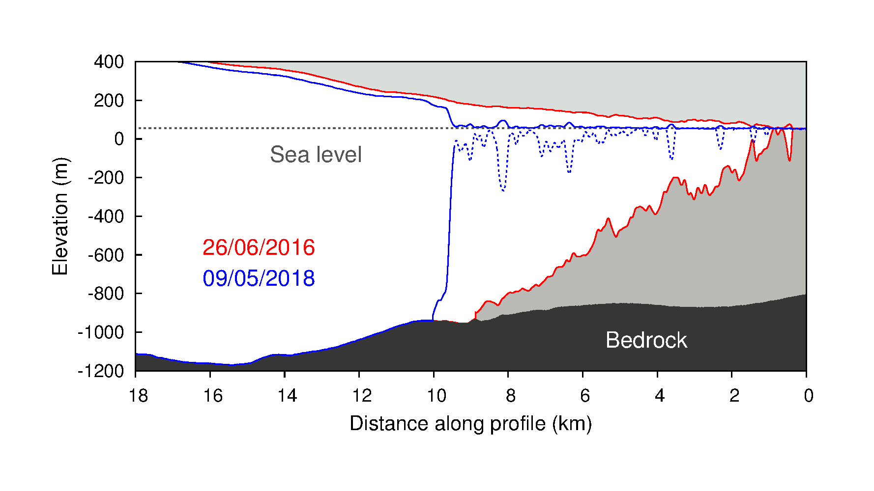
Surface height profiles
Surface height profiles along the line marked in Image 1, derived from the digital elevation models shown in Image 3. Credit: DLR (CC-BY 3.0).
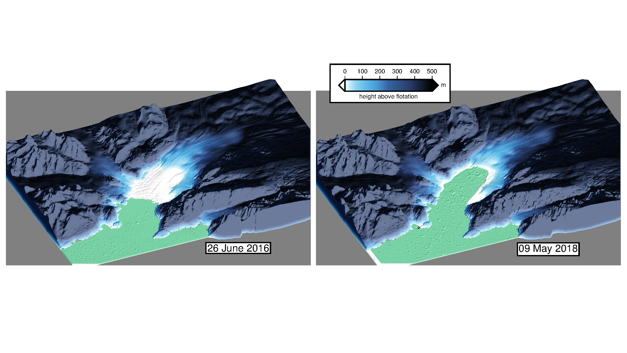
Retreat of the glacier tongue
Wherever the glacier surface is above the flotation height, the glacier is resting on the ground. By 9 May 2018, after two years of retreat, the glacier had lost its five-kilometre-long floating tongue. (Topography of the rock under the ice from IceBridge BedMachine Greenland, Version 3.) Credit: DLR (CC-BY 3.0). Focus: space, Earth observation, climate change The Kangerlussuaq Glacier is the largest glacier on the southeast coast of Greenland and flows into the fjord of the same name. The glacier front, which in the past was protected by an ice mélange – a mixture of sea ice and calved icebergs – is retreating at an increasing rate. The glacier calves approximately 24 cubic kilometres of ice into the ocean every year. This corresponds to about five percent of the amount of ice lost annually by the entire Greenland ice sheet. Using a time series of 150 TanDEM-X elevation models of the Kangerlugssuaq Glacier, scientists from Swansea University in the United Kingdom have measured the decrease in the glacier’s surface height. Glacier physics in the Arctic Ocean Glaciers are very sensitive to temperature changes because they are in direct contact with the sea and the atmosphere. Normally, in winter, an ice melange forms a natural protective shield that restricts or even completely prevents the calving of ice masses. During the summer months, the protective shield is not present, and the calving rate of the glacier increases. Glaciers lose thickness faster when they retreat horizontally. Glaciologist Suzanne Bevan and her colleagues mapped the depth of the glacier bed and fjord floor – and thus determined exactly where the glacier is floating in the water and where it is resting on the land. A comparison of the maps over the two years shows a seasonal advance as well as a clear retreat of the glacier ice front – in addition to the usual slight thickness fluctuations over the seasonal cycle. This has resulted in an elongation, referred to as dynamic thinning and has led to a lowering of the glacier surface. The maps show that between 2016 and 2018 the glacier lost most of its five-kilometre-long floating tongue. In the same period, its thickness decreased by a total of 35 metres, which corresponds to approximately 35 percent. The TanDEM-X radar satellite mission TanDEM-X was initiated on behalf of DLR with funding from the German Federal Ministry for Economic Affairs and Energy (BMWi) in public-private partnership with Airbus Defence and Space. DLR is responsible for the scientific use of the TanDEM-X data, the planning and execution of the mission, the control of the two satellites and the generation of the digital elevation models. The DLR Microwaves and Radar Institute, and the German Remote Sensing Data Centre (DFD) are all involved in the TanDEM-X mission. Together, these institutes address all relevant areas of work, from sensor technologies and mission design to high-precision operational processing and refined user products. Together with the DLR German Space Operations Center, they are also responsible for the ground segment – the infrastructure for operating the satellites and processing the data. The scientific management falls under the remit of the DLR Microwaves and Radar Institute at the DLR site in Oberpfaffenhofen. Prospects for Tandem-L DLR has also already designed a possible follow-up mission to TanDEM-X. The Tandem-L mission concept envisages two radar satellites operating in the L-band (23.6-centimetre wavelength) and designed to record dynamic processes on Earth’s surface globally and systematically. The target of Tandem-L is to map Earth’s entire landmass on a weekly basis. The mission will set new standards in Earth observation, observe global change at a new level of quality and enable important recommendations for action. The new technology could be used to record the three-dimensional structure of vegetation and ice-covered areas or to measure deformations over large areas with millimetre accuracy.
|
| URL | 查看原文 |
| 来源平台 | German Aerosapce Center |
| 文献类型 | 新闻 |
| 条目标识符 | http://119.78.100.173/C666/handle/2XK7JSWQ/135588 |
| 专题 | 地球科学 |
| 推荐引用方式 GB/T 7714 | admin. Tidal glaciers in Greenland – TanDEM-X elevation models show strongest decline in 80 years. 2019. |
| 条目包含的文件 | 条目无相关文件。 | |||||
| 个性服务 |
| 推荐该条目 |
| 保存到收藏夹 |
| 查看访问统计 |
| 导出为Endnote文件 |
| 谷歌学术 |
| 谷歌学术中相似的文章 |
| [admin]的文章 |
| 百度学术 |
| 百度学术中相似的文章 |
| [admin]的文章 |
| 必应学术 |
| 必应学术中相似的文章 |
| [admin]的文章 |
| 相关权益政策 |
| 暂无数据 |
| 收藏/分享 |
除非特别说明,本系统中所有内容都受版权保护,并保留所有权利。


修改评论