Global S&T Development Trend Analysis Platform of Resources and Environment
| New volcano monitoring tool to be trialled in Papua New Guinea | |
| admin | |
| 2019-02-13 | |
| 发布年 | 2019 |
| 语种 | 英语 |
| 国家 | 澳大利亚 |
| 领域 | 地球科学 |
| 正文(英文) |
 Remote locations in Papua New Guinea will be more resilient and informed about volcano hazards than before with the next stage in an Australian study to be trialled in Rabaul. Geoscience Australia recently published a proof of concept study, which explores the use of satellite monitoring to detect volcano deformation across high-risk volcanoes in Papua New Guinea. The study published in the journal Frontiers in Earth Science combines Interferometric Synthetic Aperture Radar (InSAR) and Global Navigation Satellite Systems (GNSS) data into a method that enables volcano observatories to use the information to make decisions on the eruptive state of volcanoes. The new remote sensing method will now be trialled by staff at the Rabaul Volcano Observatory in Papua New Guinea, following its successful application to historical data for the region by Geoscience Australia.
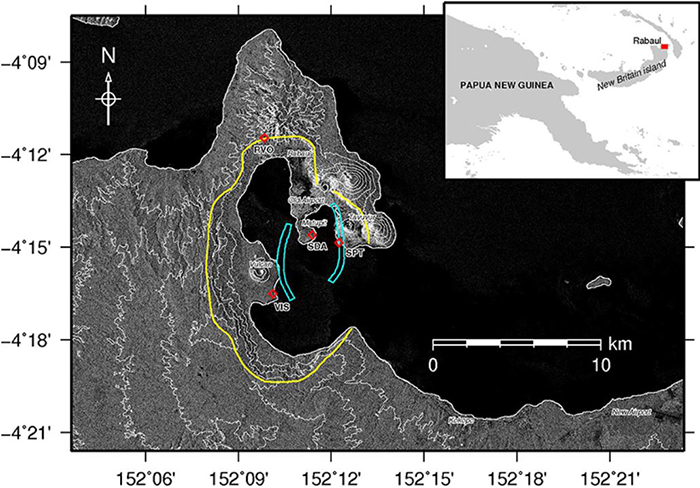
Satellite radar image of the Rabaul Caldera on New Britain Island. The yellow line indicates the boundary of the Rabaul Caldera volcano complex. Blue polygons show two zones of concentrated seismicity that occurred between 1971 and 1992 that indicated movement of magma beneath the volcano. The red diamonds are the locations of GNSS monitoring stations operated by the Rabaul Volcano Observatory. Geoscience Australia’s Chief of Positioning and Community Safety Division, Dr Andy Barnicoat, said this latest publication is the result of many years of work looking at different ways to reduce the risks of volcanoes in regional and remote locations. “Geoscience Australia has been working with Papua New Guinea to develop fundamental information and practices for the effective response and management of natural hazards for over 30 years,” Dr Barnicoat said. “Through this work, it was identified that the Rabaul Volcano Observatory in Papua New Guinea was physically limited in their ability to monitor the 56 volcanoes across the country. “Geoscience Australia has since trialled the use of remote sensing to monitor the activity of high-risk volcanoes using InSAR and GNSS. “This new method gives our Papua New Guinea neighbours the opportunity to exploit openly available satellite data, such as the European Sentinel-1 mission, and pin point where to focus attention across their active volcanoes.”
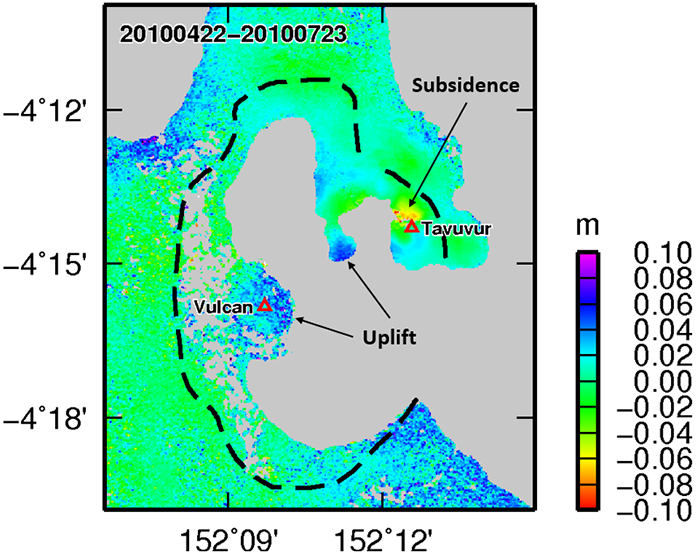
The new method uses InSAR observations to determine where, and at what depth the volcano magma chamber is located. By monitoring the changes of volume of this magma chamber, the volcano observatory can make decisions about the eruptive state of the volcano. This image shows InSAR observations of ground movement that occurred at the Rabaul caldera between 22 April 2010 and 23 July 2010. Uplift (positive values) was observed above the caldera magma chamber, whereas localised subsidence (negative values) was observed near the active volcano, Tavuvur. The Department of Foreign Affairs and Trade (DFAT) funds the Disaster Risk Reduction Program at Geoscience Australia through the Australian Aid technical exchange program between Australia and Papua New Guinea. A DFAT spokesperson said the Australian Government has been supporting the work of Papua New Guinea’s national volcanological agency, the Rabaul Volcano Observatory, since the mid-1980s. “Australia’s geoscience collaboration with Papua New Guinea over this time has been very productive, resulting in the development of new maps, modelling and infrastructure to better manage geological hazard risks across Papua New Guinea,” the spokesperson said. The publication is available online: https://www.frontiersin.org/articles/10.3389/feart.2018.00240/full |
| URL | 查看原文 |
| 来源平台 | Geoscience Australia |
| 文献类型 | 新闻 |
| 条目标识符 | http://119.78.100.173/C666/handle/2XK7JSWQ/104476 |
| 专题 | 地球科学 |
| 推荐引用方式 GB/T 7714 | admin. New volcano monitoring tool to be trialled in Papua New Guinea. 2019. |
| 条目包含的文件 | 条目无相关文件。 | |||||
| 个性服务 |
| 推荐该条目 |
| 保存到收藏夹 |
| 查看访问统计 |
| 导出为Endnote文件 |
| 谷歌学术 |
| 谷歌学术中相似的文章 |
| [admin]的文章 |
| 百度学术 |
| 百度学术中相似的文章 |
| [admin]的文章 |
| 必应学术 |
| 必应学术中相似的文章 |
| [admin]的文章 |
| 相关权益政策 |
| 暂无数据 |
| 收藏/分享 |
除非特别说明,本系统中所有内容都受版权保护,并保留所有权利。


修改评论