


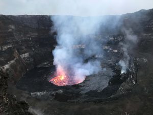
15 May 2018–Nyiragongo in the Democratic Republic of the Congo is among the world’s most active volcanoes, with a persistent lava lake as one of its defining features. In a talk at the 2018 SSA Annual Meeting, Adrien Oth of the European Center for Geodynamics and Seismology discussed how he and his colleagues are using multiple methods to monitor lava lake levels at the volcano.
The researchers analyze seismic and infrasound signals generated by the volcano as well as data collected during satellite flyovers to measure Nyiragongo’s lake level fluctuations. During the eruption in 2002, which caused a major humanitarian crisis, the lava lake was drained and the depth of the remaining crater was estimated between 600 and 800 meters. About four months after the eruption, the crater started filling up again. Nowadays, the inner crater floor is about 400 meters below the rim and the lava lake remains at high level.
“The lava lake level is, among other things, related to the variations of the pressure inside the magmatic system underneath Nyiragongo volcano,” Oth and his colleagues explained.” In that sense, the lava lake represents a window into the magmatic system, and its level fluctuations provide information on the recharge and drainage of the magmatic system, such as batches of fresh magma and/or gas, or lateral magmatic intrusions into the surrounding crust.”
The different techniques used to observe the lava lake offer a more complete look at the volcano’s activity, the authors said. The seismic and infrasound data, collected continuously, help researchers gauge pressure changes in magmatic activity. “Until very recently, very few high-quality data were available for this region,” the researchers noted.” Over the past few years, our consortium assisted the Goma Volcano Observatory to deploy one of the densest modern real-time telemetered monitoring systems in Africa. Combined with modern processing techniques, these newly acquired datasets provide unprecedented opportunities to investigate the behavior of this unique magmatic system.”
In combination with seismic and infrasound data, the scientists are using high resolution synthetic-aperture radar (SAR) images captured by satellites passing over the volcano to directly measure the rise and fall of the lava lake level. These images measure the length of the shadow cast by the crater’s edge on the lava lake surface, which can be used to calculate the lava depth.
The lava lake observations are only one piece of the puzzle within the regional volcanic system, and “will certainly be of key importance for successful eruption forecasting in the future,” said Oth and colleagues. “At this stage, however, these observations need to be first put into the larger context of the magmatic system in order to allow their proper interpretation in terms of eruptive processes.”
修改评论